Writing you on my way home from experiencing the outdoors and city life that Nepal has to offer, I thought I’d pick up where I left off (mid trek), and take you along the rest of our journey. Time really does fly, and it’s hard to believe that I did leave you in Namche over 10 days ago. So, what was the rest of the trek in to Everest Base Camp like?
April 13, 2019: Namche (3440m) to Pangboche (3950m) via Tengboche (3875m).
This was due to be one of the longer days on our journey: 13km more. We were briefed it would be 3-4hrs to Tengboche and then another 2-3hrs our rest stop. Although on paper, it seemed like a gentle climb of 500m up with 100m down, this is where we were introduced to the Nepali Downhill. The Strava account informed us that on the first portion of the hike alone, we did 9.4 km with 900m of elevation gain spread over the undulating hillside. No wonder I felt absolutely bagged by the time we reached our half-way time point.
Tengboche, although small, is known for two reasons: a Buddhist Monastery and excellent bakery. In fact in all of the media Robin and I consumed, we saw the bakery in an episode of Everest Air Rescue. Not for undue reasons, rather that one of the junior helicopter pilots was sent to pick up a birthday cake for the rest of the group. I don’t blame him! I would not want to do that hike again if I didn’t have to and the cake was deeee-licious!
We had our cake and ate it, too as we waited for Dawa Choling Gompa to reopen after lunch. Basic from the outside and incredibly ornate within. I will ask you to use your imagination as there were no photos allowed, but beyond the coloured Chinese gate, past the white facade dotted with dark brown trapezoidal windows, a courtyard led way to the main interior meditation room. So brightly coloured as it was recently (in the mid ‘90’s) restored after a fire, the walls depict various allegories from Buddhist history. Feeling grounded from the visit as thousands of past trekkers have who have made this visit, we continued forth.
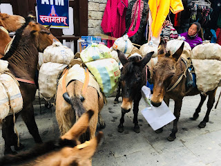
The scenery for our 4hr/1.5hr split was much of the same as the first days, with the dirt/ stone pathways, dotted religious stones (now I know are called Mani stones), and yak-dodging. Unfortunately, we lost the views in the steadily moving clouds taking away the upper mountains which surround us as we trek. This was also to be the last day of trees as we made our way higher to the heavens.
We arrived (bagged, well at least I was, as mentioned) to our one night home called the Sonam Lodge in Pengboche. The standard of accommodation certainly declined since Namche, and everything is far more rustic. You can read more details about the Tea Houses in my previous entry.
April 14, 2019: Pangboche (3950m) to Dingboche (4410m)
We started the day with our usual briefing to learn our next village should be a 3-4hr trek, so when we arrived in Dingboche in just under 2 hours, we were pleasantly surprised (and relieved!). The Yak Hotel and Restaurant would be our home for two nights.
As mentioned, today the terrain changed. We said goodbye to the trees. There were now large boulders amongst lower shrubs and slopes of large rocks to the sides of us. The weather changed, as well. It was time to unpack the warmer layers as the warmth from the sunshine quickly passed early in the day to leave us with wind, clouds, and a hail storm.
En route we had heard news that there was a crash killing 3 people at Lukla airport. The desire to know got the better of us and we spent $5 on the Tea House WiFi to find out the details: the crash happened leaving three deceased (co-pilot and two ground officers) when a crew-only plane lost control on the runway, veered to the wrong side and collided with two stationary helicopters. This was certainly a stark reminder of the dangers that lie ahead on the return to Kathmandu.
We spent the remainder of the day in what would prove to be “bustling” Dingboche searching out good bottled water prices versus those at the Tea Houses (to be found at “The Best Shop” in Dingboche), drinking Bailey’s hot chocolate at one of the local bakeries (glad I had so much money for chocolate cake), and huddled around the yak-poop stove reading to keep warm.
April 15: “Rest” day in Dingboche (4410m)
Rest day actually means acclimatisation hike day, and based on the previous acclimatisation hike, I should have taken caution rather than thinking it would be an easy day.
At the back of our hotel we saw the impending doom of switchbacks up the steep gradient with what might look to be a never ending hill. This hill in the end was a 2.5 km set of switchbacks with 700m elevation gain at 25-30% incline. Okay, so stairs are typically at a 30% gradient, but imagine doing 2.5 hours of stairs with just over half of the amount of available oxygen in the air... this training will make me faster, right?!
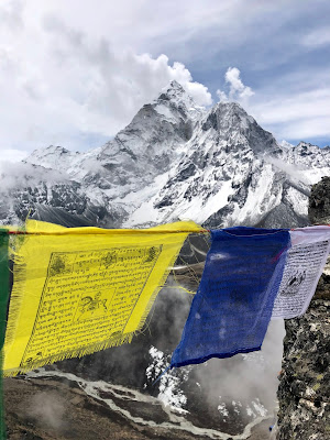
Relief came in a few ways: the weather was fabulous allowing us to see the beauty of Ama Dablam and the surrounding snow and rock landscape of 7000+ meters; we met a flag-capped summit of whatever molehill we just climbed allowing an actual sense of accomplishment to be felt; I had some emergency chocolate to hand (Cadbury Boost) and man, did that do exactly as it said on the tin! We snapped our practice summit pictures, relished in our chocolate break, and then headed down to Dingboche to rest for the rest of the rest day.
Not only does Dingboche host “The Best Shop” (every village has its own), it also hosts what I would say is “The Best” cafe of the excursion: Café 4410. A coffee shop that would fit in anywhere in the Western world. Many trekkers pass the time at Café 4410 drinking their NYC-priced latte and eating their apple pies (viable source of much needed fibre) whilst waiting for their phones to charge (free with purchase). Time is also passed by blogging, reading a variety of famous climbing books or playing hours of board games: Monopoly, chess and Jenga being the most popular games.
April 16: Dingboche (4410m) to Lobuche (4900m or 4930m or 5030m depending on which sign you read)
We seem to have gone off piste to the “itinerary” here, bypassed what was a scheduled overnighter in Dugla, and continued onto our next town, higher than any point in Western Europe. Another 3-4 hours of an 8.3km trek with 600+ m of steady upwards elevation, the greenery has now all completely vanished and we are left with boulders along the carved river valley that we follow. Clear skies allow us the views of the surrounding peaks and to feel the strength of the sun in the thinner air.
We pass the sobering and monumental Climbers’ Memorial, an area decorated with flags, Mani Stones, and plaqued altars. The names of previous climbers who have lost their lives pursuing their endeavours within the Himalayas are presented on these hand-stacked altars dotted around the hillside. There are names of the outwardly well-known, in addition to the everyday men and women who met their fate at the mountain, not just at Everest. We pay respect to the lost climbers, as well as to the mountain before continuing forth.
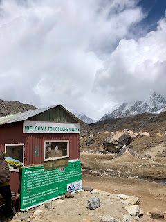
Entering into Lobuche, we are familiar now with what to expect…. Check-in point, sign saying 6km to EBC (so close!), The Best shop, The World’s Highest Bakery, and a few Tea Houses looking more and more basic. There is rumour that there is a “posh” Tea House here, which Robin and I go to check to see if it is worth staying the night. It’s a little warmer, friendlier, and more brightly painted, perhaps reminiscent of the earlier Tea Houses along the way. However, we decide to stick to the group and stay our one night at Above the Clouds before departing to my end goal the following day.
April 17, 2019: Lobuche (5030m) to Gorak Shep (5164m) to Everest Base Camp (5364m)
We are off to EBC!!
Slightly nervous based on my Kilimanjaro experience and because as we upped the ante each day resulting in a slight headache, as a precautionary measure I started on the Diamox this morning. Half a tablet, twice a day (based on my body size) should thin my blood just enough to relieve a slight pressure build up in my head. I found that from about 4000m onwards, I’d finish the hike with a headache that would subside after drinking 1L of water and having a nap, and I would feel fresh (except for heavy legs) the next morning.
We woke up to a cold (-3C) and snowy scene, which meant two things: one, I had all new, clean clothes to put on which I had been saving for the colder temperatures and two, for the duration of the hike, we would here reference to being “North of the Wall” possibly as it was also nearing the premier time for Game of Thrones.
Although the air was cold and snow afoot, the morning sun was strong and as we set out from our last bed, many of us overheated in about 10 minutes. I was certainly starting to feel fatigued from the past 7 days of ascent. As we were at the back of the pack, our supervisor Sherpa Jangbu offered Robin, myself and two others an alternative route. Hoping that this was going to be a shortcut, we followed dutifully. It turned out Jangbu wanted to show us a picture point and hidden gem of a Tea House tucked away from the main path (and to say hello to some of his fellow friends). We had a beautiful view of the mountain Pumori, and a teaser of “what we could have had” for a Tea House. It turned out the 8000 Inn is a more upmarket Tea House (still basic vs a hotel) coupled with a research station. This was where the National Geographic Team were staying en route.
After our photo stop, we continued to follow Jangbu along the back route: a side hill ridge route with a path only just big enough to hold both feet side-by-side at the widest points before plunging 400m down the valley to the conventional path where we could see the rest of the trekkers. Last time Robin and I walked this type of route, we had crampons, an ice axe to hand, and safety line between us (similar to what was the Grand Couloir on Mont Blanc). Dry dirt covered by about 3 cm of sticky snow now melting in the sun made for some precarious footwork. Each step was deliberate and anchored by walking poles planted to the front of our bodies acting in safety if we should slip. There was no sense nor time to panic or we may slip down the face into the valley with no chance of stopping ourselves. The two split seconds I felt comfortable and shifted by attention were coupled with heart-racing wobbles. It took us about an hour to get across this part of the path. Oh, and the route was 1km further than that of our fellow trekkers!
The Jangbu group of four were briefly reunited with our fellow trekkers at Gorak Shep, a village of a handful of establishments en route to EBC. We stopped for lunch and respite just as a the others were leaving. Refuelled, warm, and with a headache coming on, we geared up and proceeded to our destination.
About 90 minutes and a final slowly, slowly, step-by-step climb later, we made it to EBC!
We found the decorated rock to take our pictures, waited our turn, and jumped in. The pictures we took are a testament to how tired I must have been because they were awful. The only sense of relief was that we were nearer to our tent. The whole event felt ever-so anticlimactic. This would be/ should be an achievement of a lifetime to many people, and yet the feelings of accomplishment for such a feat were missing. Perhaps because I’ve done bigger things, perhaps because I managed my expectations too well. I have felt in the past accomplishment comes when I have surmounted my expectations. As well and partially because of what I alluded to earlier, EBC is NOT the top…. there are still thousands of meters more. Not that I am ungrateful for the past week of rich experience, rather that rationally I know it’s not the finale. We’ve set the scene. Act I is complete. The protagonist, Robin, will continue onward and upwards through Act II and the Finale over the next month. As I write this last sentiment, a smile comes to my face as I feel excited and proud of the endeavor he has on his plate. I’m sure the missing sense of accomplishment will come when Robin has finished his story.


